
Craig:
The small size of the community and slow traffic speeds makes Craig a bicycle friendly community, despite not having bicycle lanesor paved shoulders. The community is located 32 miles from the Inter-Island Ferry terminal in Hollis with sailings from Ketchikan.The roadway from Hollis to Craig is paved and makes a good cycling route however large fast moving vehicles and logging trucks alsouse the road. Use caution.
Craig is the largest community on Prince of Wales Island and has limited bicycle facilities and services. JS Warehouse True ValueHardware is located at 510 Port Bagail Blvd; 907-826-3632 and provides basic cycling parts. Craig has a basic level of service forcyclists at Shaub-Ellison Tire & Fuel/Car Rentals, 1505 Craig-Klawock Highway; 907-826-3450. Interpretive and recreation informationcan be found at the USDA Forest Service’s Craig Ranger District Office, 900 9th Street, Craig; (907) 826-3271. The nearestcommunities providing full cycling services is Ketchikan.
There are numerous recreation facilities (cabins, campgrounds, wildlife viewing, and trails) managed by the USDA Forest between the Hollis terminal and the community ofCraig. http://www.fs.fed.us/r10/tongass/districts/pow/recreation/rec_map.shtml.
Summary:
Graveyard Island Trail is located on the south edge of downtown Craig at the end of Hamilton Drive on Cemetery Island. The hardpacked gravel trail follows the east shore of Cemetery Island and terminates at Cape Suspiro. The trail is used by hikers and cyclistsand is near level. The route can be used by road or mountain bikes.
Activity:
Road and moiuntain bikingwith hiking use
Intrinsic Qualities:
Scenery, Cultural, Historic
Length:
3/4 miles one way
Elevation:
Less than 30 feet in elevation gain. This trail is not designated as an ADA trail; however, it can be used by a wide array of users
Difficulty:
Easy: This is a level hard packed gravel trail without obstacles or hazards. Watch for wildlife (bears, deer) and hikers on the trail.
Starting Point:
This bike trails begins at the end of Hamilton Drive off the Craig-Klawock Road at the south end of downtown at the Craig Cemetery.
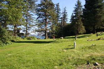
Graveyard:
Photo of the historic graveyard near the trailhead.
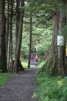
Trail Photo:
Example of trail condition with a bicyclist riding in distance.
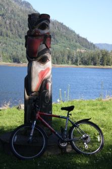
Totem:
A totem pole alongside the trail.
Google Earth File:
Click HERE to download a Google Earth file of the bicycleroute. To view profile in Google Earth, right-click on the route in the ‘Places’ window and choose ‘ShowElevation Profile.’ Note: Trail route is approximate. Also, the 8/2003 imagery that Google uses is slightly shifted. Therefore,part of the route appears to be in the water.
Weather:
HERE isthe official National Weather Service forecast for the trail location. To view the current FAA webcam image from Craig, click HERE.
![]()